


Stevenson étape 8: Chasserades --> Le Bleymard

BernardPONS
User
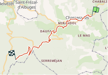

Length
13.2 km

Max alt
1431 m

Uphill gradient
410 m
Km-Effort
18.5 km

Min alt
1093 m

Downhill gradient
362 m
Boucle
No
Creation date :
2019-06-05 07:03:02.096
Updated on :
2019-06-05 17:30:02.766
3h29
Difficulty : Easy

FREE GPS app for hiking
 SityTrail
IGN / Geographical institutes
SityTrail Plus
The world is yours!
About
Trail Walking of 13.2 km to be discovered at Occitania, Lozère, Mont Lozère et Goulet. This trail is proposed by BernardPONS.
Positioning
Country:
France
Region :
Occitania
Department/Province :
Lozère
Municipality :
Mont Lozère et Goulet
Location:
Chasseradès
Start:(Dec)
Start:(UTM)
567006 ; 4933687 (31T) N.
Comments